Vancouver, British Columbia--(Newsfile Corp. - April 20, 2021) - Cross River Ventures Corp. (CSE: CRVC) (FSE: C6R) (the "Company") is pleased to update shareholders on the progress of the 2021 exploration plans at its portfolio of gold projects, located in NW Ontario, Canada.
McVicar Gold Project
Cross River's approximately 11,500-hectare McVicar Gold Project encompasses the recent consolidation of multiple properties that cover the Lang Lake greenstone belt located in the Patricia Mining Division, approximately 150 km east of Red Lake, and 80 km west of Pickle Lake, in NW Ontario, Canada.
Eagle Mapping Ltd. will fly a LiDAR survey of the property as soon as conditions allow. The survey will create a high-resolution topographic map to identify shear zones and structural features. The Company plans to use this data to enhance structural understanding and focus in on the most prospective zones for gold mineralization, to be further assessed in the field.
The Company has also contracted Bayside Geoscience Inc. for targeted field work (prospecting, sampling, delineating known showings) based on technical geological analysis and historical data review. The 4-week program is scheduled to commence in June, after results from the LiDAR survey are received and analyzed.
The field program will focus on high potential structural zones (i.e., Bear Head Fault zone, Altered Zone shear, Lang Lake deposit, and the unexplored Cannon Lake Fault zone). The Cross River technical team will also conduct site visits to assess priority targets during this field work campaign.
In addition to the Bayside field team, the Company has engaged GroundTruth Exploration Inc. for a 2-month Geoprobe Bedrock Interface sampling campaign at McVicar scheduled to begin late July.
The Geoprobe survey will directly follow-up the LiDAR survey and field work. The Geoprobe will be used to rapidly sample bedrock surface through overburden with no environmental impact and maximum efficiency. It will allow the Company to further delineate high priority targets defined by LiDAR and field investigations.
The Geoprobe survey will begin near the Chellow Vein (up to 827 grams-per-tonne gold sampled in quartz veins: McKay, 2003), with the goal of tracing known gold-bearing shear zones along strike and identifying potential for prospective parallel structures.
The Company's data compilation at McVicar has uncovered 1000s of data points from rock samples and historic trenching including assays, alteration, lithology, structural data, and detailed maps from across the property. Additionally, historic drillhole data for almost 200 holes, containing 1000s of assay and logging intervals, is currently being interpreted in Leapfrog to gain a 3-D understanding of targets such as the Altered Zone and Chellow Vein.
"Our exploration plans have been progressing as scheduled," said Alex Klenman, CEO. "The technical team has been hard at work combing through historical data, gaining a complete understanding of all the geological components of McVicar and the other projects. We're now ready to enter the next phase of work, which leads us to field work, and ultimately, drilling. It's all about quality target generation, and the methodical approach taken here gives us what we feel is the most effective roadmap to impactful discovery," continued Mr. Klenman.
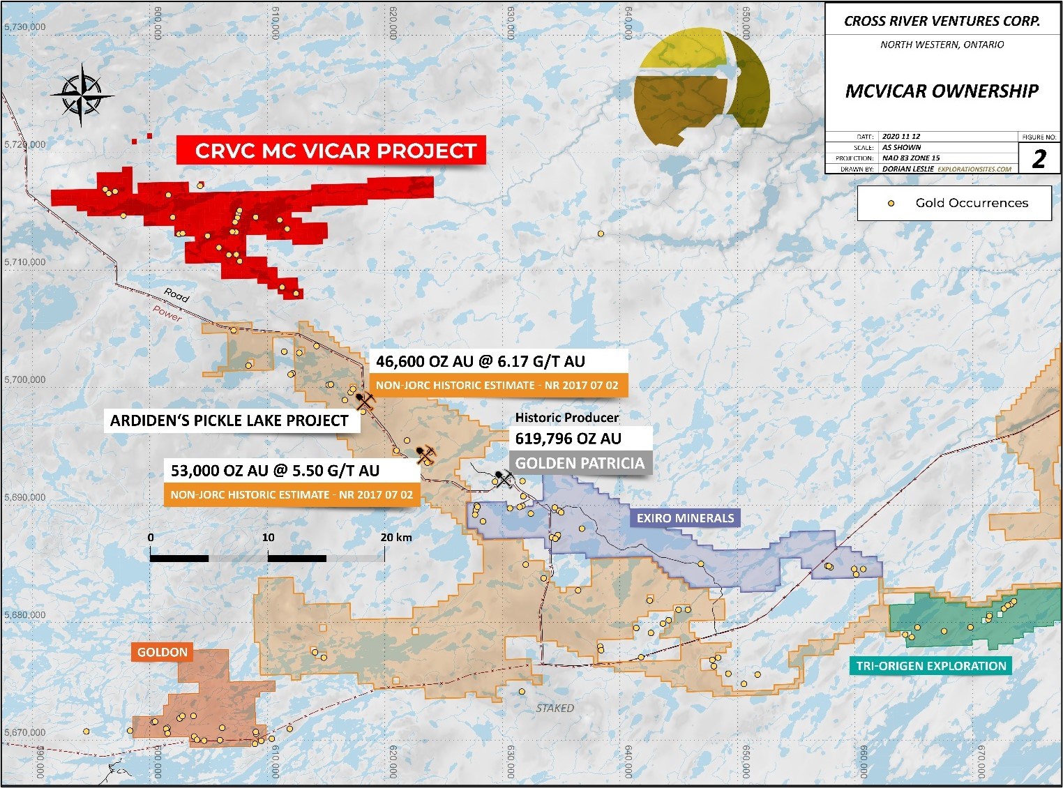
Figure 1: McVicar Gold Project, Lang Lake Greenstone Belt, NW Ontario, Canada
To view an enhanced version of Figure 1, please visit:
https://orders.newsfilecorp.com/files/7276/80988_4850d46f34dfd847_002full.jpg
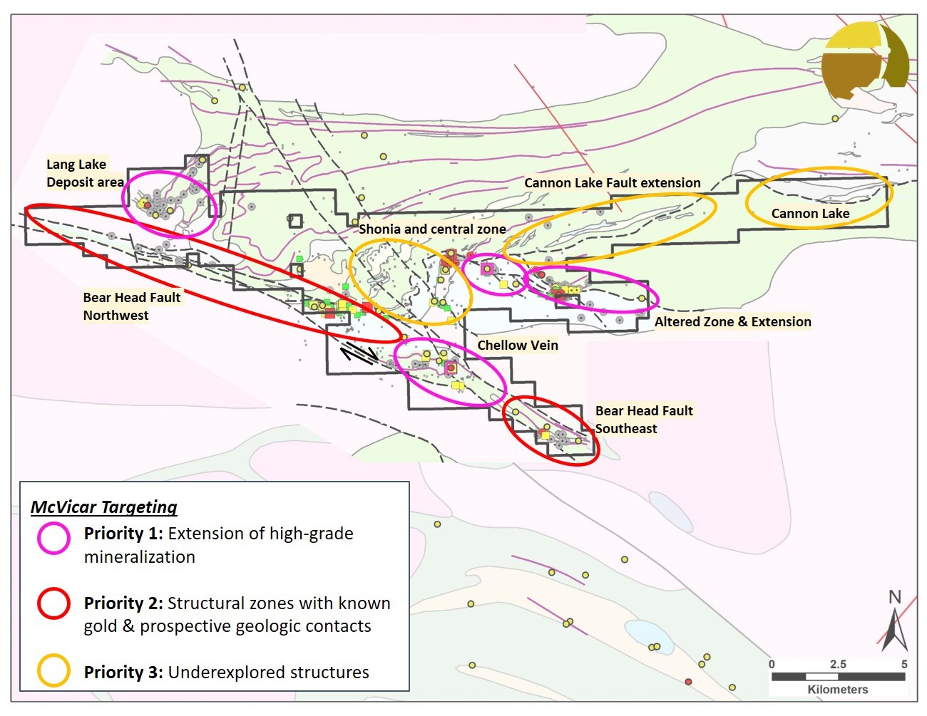
Figure 2: McVicar Target Areas, Lang Lake Greenstone Belt, NW Ontario, Canada
To view an enhanced version of Figure 2, please visit:
https://orders.newsfilecorp.com/files/7276/80988_4850d46f34dfd847_003full.jpg
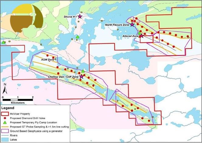
Figure 3: Proposed permit activities, McVicar Gold project, NW Ontario, Canada
To view an enhanced version of Figure 3, please visit:
https://orders.newsfilecorp.com/files/7276/80988_4850d46f34dfd847_004full.jpg
Exploration permit applications for the McVicar Gold project have been submitted and are currently in circulation. The Company anticipates receiving necessary approvals by late April.
Uchi Belt and Manitou Properties
Bayside Geoscience has been contracted for targeted field work (prospecting, sampling, delineating known showings) planned to commence in mid-May on the remaining Cross River Ontario properties (Manitou, Shabu, Dent Lake, Maskooch, and Ear Falls). Timing and logistics of these field programs will be determined and announced in the coming weeks. The Cross River technical team will also be conducting site visits to assess priority targets during these field work campaigns.
The Company has completed Phase 1 Technical review and data compilation for these properties. The reviews of historic work revealed an abundance of valuable data and mineralization potential, warranting additional follow-up field work for all of the properties. Initial results will guide future field work. The technical team will be consulting with Bayside geologists to ensure field efficiency and a detailed approach to the field campaigns.

Figure 4: Shabu, Dent-Jackson, Maskooch projects, NW Ontario, Canada
To view an enhanced version of Figure 4, please visit:
https://orders.newsfilecorp.com/files/7276/80988_4850d46f34dfd847_005full.jpg
Cross River Raises $933,500
The Company is also pleased to announce that it has completed the offering of 4,667,500 units (each, a "Unit"). The Units were offered by way of non-brokered private placement, at a price of $0.20 per Unit, for gross proceeds of $933,500.00. Each "Unit" consists of one common share, and one-half-of-one common share purchase warrant (each whole warrant, a "Warrant") exercisable to acquire an additional common share at a price of $0.30 until April 20, 2023. The gross proceeds from the offering will be used for further project development work and for general working capital purposes.
In connection with completion of the offering, the Company paid finders' fees of $16,100.00, and issued 80,500 Warrants to certain arms-length parties who introduced subscribers to the offering. All securities issued in connection with completion of the offering are subject to a four-month-and-day statutory hold period, in accordance with applicable securities laws, until August 21, 2021.
* Grab samples are selective by nature and may not represent the true grade or style of mineralization across the property
The technical content disclosed in this press release was reviewed and approved by Dr. Rob Carpenter, P.Geo., Ph.D., a Qualified Person as defined under National Instrument 43-101. Historical assay results contained in this press release were not verified by the Company, however, the historical reports referenced were authored by experienced geoscientists and copies of laboratory assay sheets were commonly inserted in the reports.
About the Company
Cross River is a gold exploration company that is focused on the development of top tier exploration properties in premier mining districts. The Company controls a multiple project portfolio in NW Ontario, Canada, with highly prospective ground in and among prolific, gold bearing greenstone belts. The Company also owns an option to acquire a 100% undivided interest in the Tahsis Property, an early-stage gold exploration property located on Vancouver Island, in the Nanaimo Mining Division, British Columbia. Cross River's common shares trade under the symbol "CRVC" on the CSE.
On behalf of the Board of Directors of
CROSS RIVER VENTURES CORP.
Alex Klenman
CEO
604-227-6610
aklenman@crossriverventures.com
www.crossriverventures.com
Neither the Canadian Securities Exchange nor its Regulation Services Provider (as that term is defined in the policies of the Canadian Securities Exchange) accepts responsibility for the adequacy or accuracy of this release.
This news release may contain forward-looking statements. These statements are based on current expectations and assumptions that are subject to risks and uncertainties. Actual results could differ materially because of factors discussed in the management discussion and analysis section of our interim and most recent annual financial statement or other reports and filings with the Canadian Securities Exchange and applicable Canadian securities regulations. We do not assume any obligation to update any forward-looking statements, except as required by applicable laws.
References
References:
http://www.geologyontario.mndm.gov.on.ca/mndmfiles/afri/data/records/52O11SW2002.html
![]()
To view the source version of this press release, please visit https://www.newsfilecorp.com/release/80988